Datei:Supervolcano World Map.png

Größe dieser Vorschau: 800 × 406 Pixel. Weitere Auflösungen: 320 × 163 Pixel | 640 × 325 Pixel | 1.024 × 520 Pixel | 1.992 × 1.012 Pixel.
Originaldatei (1.992 × 1.012 Pixel, Dateigröße: 106 KB, MIME-Typ: image/png)
Beschreibung
| Beschreibung |
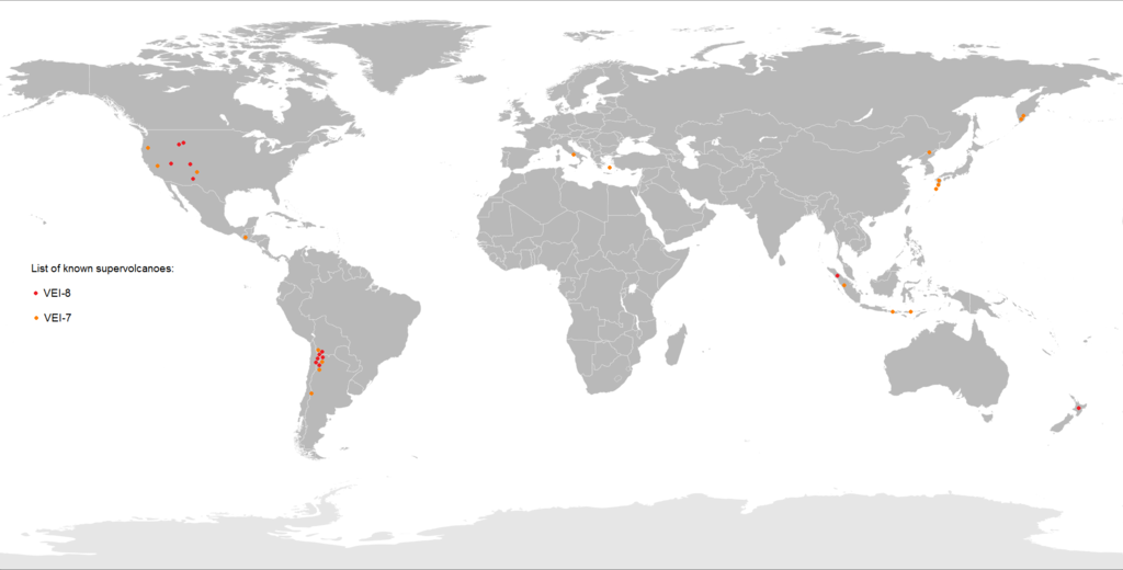
English: Map of known dormant supervolcanoes around the World.
|
| Datum | |
| Quelle | Eigenes Werk |
| Urheber | Maphobbyist |
Lizenz
Ich, der Urheber dieses Werkes, veröffentliche es unter der folgenden Lizenz:
Diese Datei ist lizenziert unter der Creative-Commons-Lizenz „Namensnennung – Weitergabe unter gleichen Bedingungen 4.0 international“.
- Dieses Werk darf von dir
- verbreitet werden – vervielfältigt, verbreitet und öffentlich zugänglich gemacht werden
- neu zusammengestellt werden – abgewandelt und bearbeitet werden
- Zu den folgenden Bedingungen:
- Namensnennung – Du musst angemessene Urheber- und Rechteangaben machen, einen Link zur Lizenz beifügen und angeben, ob Änderungen vorgenommen wurden. Diese Angaben dürfen in jeder angemessenen Art und Weise gemacht werden, allerdings nicht so, dass der Eindruck entsteht, der Lizenzgeber unterstütze gerade dich oder deine Nutzung besonders.
- Weitergabe unter gleichen Bedingungen – Wenn du das Material wiedermischst, transformierst oder darauf aufbaust, musst du deine Beiträge unter der gleichen oder einer kompatiblen Lizenz wie das Original verbreiten.
Dateiversionen
Klicke auf einen Zeitpunkt, um diese Version zu laden.
| Version vom | Vorschaubild | Maße | Benutzer | Kommentar | |
|---|---|---|---|---|---|
| aktuell | 05:28, 27. Okt. 2025 | | 1.992 × 1.012 (106 KB) | wikimediacommons>Gartok~commonswiki | Mount Batur in Bali, Indonesia, is a dormant VEI-7 volcano, which during a volcanic eruption around 20,150 years ago, ejected a minimum of 108 km<sup>3</sup> of tephra, thus exceeding the minimum 100 km<sup>3</sup> threshold of VEI-7. |
Dateiverwendung
Die folgende Seite verwendet diese Datei: