Datei:Map of Jupiter.jpg

Datei:Map of Jupiter.jpg

Originaldatei(2.231 × 2.266 Pixel, Dateigröße: 426 KB, MIME-Typ: image/jpeg)

Diese Datei stammt aus Wikimedia Commons und kann von anderen Projekten verwendet werden. Die Beschreibung von deren Dateibeschreibungsseite wird unten angezeigt.

Wikipedia

 Dies ist eine exzellente Datei in der Wikipedia auf Englisch (Featured pictures) und wird als eine der hervorragendsten Bild-Dateien gewertet.

Wenn du meinst, diese Datei sollte auch auf Wikimedia Commons ein exzellentes Bild werden, dann kannst du sie nominieren.
Wenn du ein Bild vergleichbarer Qualität hast, das du unter einer passenden freien Lizenz freigeben kannst, dann lade die Datei hoch, gib ihr eine korrekte Lizenzangabe und nominiere sie!

Beschreibung

Beschreibung
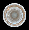
English: :This map of Jupiter is the most detailed global color map of the planet ever produced. The round map is a polar stereographic projection that shows the south pole in the center of the map and the equator at the edge. It was constructed from images taken by Cassini on Dec. 11 and 12, 2000, as the spacecraft neared Jupiter during a flyby on its way to Saturn. The map shows a variety of colorful cloud features, including parallel reddish-brown and white bands, the Great Red Spot, multi-lobed chaotic regions, white ovals and many small vortices. Many clouds appear in streaks and waves due to continual stretching and folding by Jupiter's winds and turbulence. The bluish-gray features along the north edge of the central bright band are equatorial "hot spots," meteorological systems such as the one entered by NASA's Galileo probe. Small bright spots within the orange band north of the equator are lightning-bearing thunderstorms. The polar region shown here is less clearly visible because Cassini viewed it at an angle and through thicker atmospheric haze.
Datum 11-12 December 2000
Quelle From http://www.nasa.gov/multimedia/imagegallery/image_feature_539.html
Urheber NASA/JPL/Space Science Institute
Genehmigung
(Weiternutzung dieser Datei)
PD-USGOV-NASA.
Andere Versionen

Lizenz

Public domain Diese Datei ist gemeinfrei (public domain), da sie von der NASA erstellt worden ist. Die NASA-Urheberrechtsrichtlinie besagt, dass „NASA-Material nicht durch Urheberrecht geschützt ist, wenn es nicht anders angegeben ist“. (NASA-Urheberrechtsrichtlinie-Seite oder JPL Image Use Policy).
Warnung:

Dateiversionen

Klicke auf einen Zeitpunkt, um diese Version zu laden.

Version vomVorschaubildMaßeBenutzerKommentar
aktuell10:59, 14. Feb. 2007Vorschaubild der Version vom 10:59, 14. Feb. 20072.231 × 2.266 (426 KB)wikimediacommons>Helix84{{en| :This map of Jupiter is the most detailed global color map of the planet ever produced. The round map is a polar stereographic projection that shows the south pole in the center of the map and the equator at the edge. It was constructed from images

Die folgende Seite verwendet diese Datei:

Metadaten

Die News der letzten Tage